Peaks Of The Balkans – Route, 10 Stages, Permits

By Dirk, adventure traveler, originally from Germany. I visit every place I write about & share real tips, photos, & advice from my trips.
The trail connects the borders of Albania, Montenegro, and Kosovo and offers both a unique outdoor adventure and an unrivalled cultural experience.
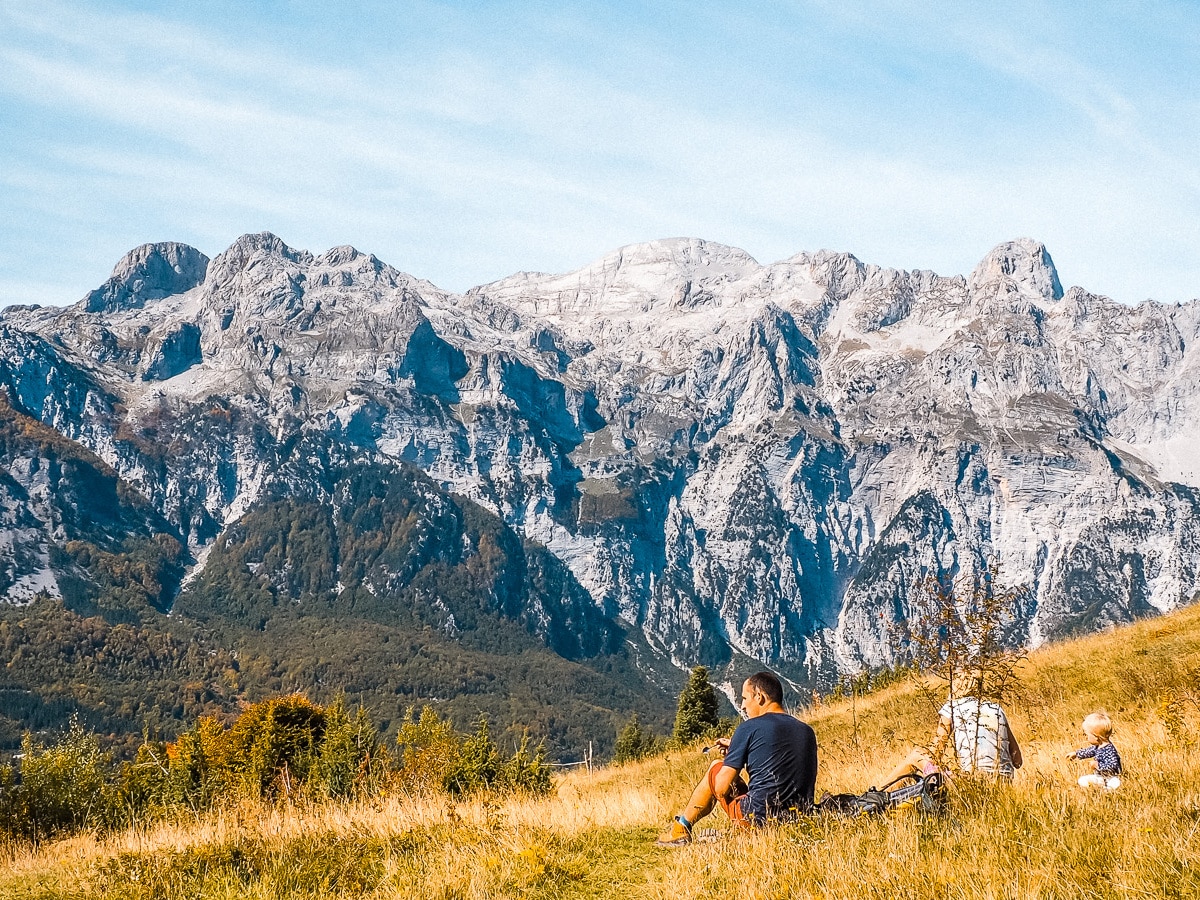
‘Peaks of the Balkans”: The long-distance hiking trail through Albania, Montenegro and Kosovo is characterised by the impressive formations of the Prokletije karst mountains, spectacular views of lush valleys and the kindness and hospitality of the people. Always between 700 metres and 2,500 metres above sea level, the trail leads you to natural gems and beautiful little towns such as the Albanian town of Theth and the Montenegrin town of Plav. Alpine hiking pleasure without mass tourism in a historically and socially fascinating region of the world!

Table Of Contents
What an experience: the three-country trail ‘Peaks of the Balkans’ stretches for around 200 kilometres and over 10,000 metres in altitude! You hike along former shepherds’ paths through border regions that have undergone an exciting development thanks to subsequent eco- and hiking tourism. Nevertheless, you are far away from any mass tourism.
Peaks of the Balkans Self-guided


In ten one-day stages, you will hike from Theth via Valbona to the rugged high valleys of Dobërdol and Milishevc. In Kosovo, you enjoy a brief moment of comfort near the red rock “Guri i Kuq” before climbing up again and finally reaching the picturesque little town of Plav. From there, you hike over spectacularly beautiful ridges and high valleys in the middle of the Prokletije karst mountains back to Theth.
Your hiking adventure on the Peaks of the Balkans Trail
What is the Peaks of the Balkans Trail?
The idea of the trail was to offer a culturally interesting outdoor adventure that also helps to support local families in remote mountain areas.
The trails was established by shepherds and soldiers in the beginning in an effort to connect isolated mountainous regions. That quickly changes when you consider the turbulent history of the region and the once strictly controlled borders. What seems normal today, crossing national borders with relative ease, would have been impossible a few years ago. With a new border crossing application system, you can now tackle this unique trek that connects the most amazing mountain areas of Albania, Kosovo and Montenegro.
Peaks of the Balkans Trail Map

Route
The Balkan Trail route is not a single path, but a concept that connects the three different countries within a shared mountain region. Depending on your personal preferences, you can choose between countless different route options. While the original route is considered the most efficient for those who decide to be independent, travelling without transport and with a tent.

However, it is not necessarily the most beautiful or best option, as many unpaved forest roads were included as a compromise solution when countries demanded equal portions of the route. These sections can be replaced by more scenic hiking routes in adapted tours and can be skipped or shortened with short transfers. This allows you, for example, to climb one of the many peaks along the route or to include a detour to the amazing Grbaja Valley and the interesting Kelmend region.

Stages
The Peaks of the Balkans is a circular hiking trail – so you can choose between different starting points in the three countries. The most popular are the following:
- Shkoder (Albania)
- Peja (Kosovo)
- Plav (Montenegro)
The following table shows you the usual sequence of stages with the starting point in Theth near Shkoder in Albania:

The classic route is divided into 10 stages:
- Stage 1: Theth, Albania – Valbonё, Albania
- Stage 2: Valbona, Albania – Çerem, Albania
- Stage 3: Çerem, Albania – Doberdol, Albania
- Stage 4: Doberdol, Albania – Milishevc, Kosovo
- Stage 5: Milishevc, Kosovo – Reka Allages, Kosovo
- Stage 6: Reka e Allagёs – Pepaj – Drelaj – Dugaivё – Kucishtё, Kosovo
- Stage 7: Liquenat I Kucishtes, Kosovo – Babino Polje, Montenegro
- Stage 8: Babino Polje, Montenegro – Hrid lake – Plav, Montenegro
- Stage 9: Plav, Montenegro -Bor Peak – Vusanje, Montenegro
- Stage 10: Vusanje (Vuthaj), Montenegro – Theth, Albania
Elevation profile

Difficulty and Safety
The trail itself is not really technical and generally quite safe, the official circuit and modified trails offer many ascents and descents, which can prove challenging. To hike the entire Peaks of the Balkans route, be prepared for some long days and rocky terrain. Days with ascents of 1,200 metres and then descents of 1,000 metres are common rather than the exception.

This means you can climb a summit in one day and then descend back down into the valleys to spend the night. In this way, you will cover more metres in altitude in total than on a typical Himalayan hike or a Kilimanjaro summit ascent. However, unlike the tours mentioned above, you will not reach any oxygen-depleted heights. The highest point on the hike is 2750m.
Peaks of the Balkans – Best time to hike
The best time to hike the Peaks of the Balkan Route is from mid-June to mid-October. Although it is also possible to hike here outside this period, you should be prepared for a lot of snow and possibly closed accommodation. As autumn approaches, temperatures in the Balkan Mountains begin to drop and longer periods of rain set in. The weather is most stable from July to the end of September. Nevertheless, you should always check the weather again before every hiking tour and have clothing and equipment with you just in case.
Arrival
As the hike is a circular route, it can be started and finished at various points. These are quite easy to reach from the airports in Tirana, Podgorica and Pristina.
- Shkoder (Albania) is the most common and most popular starting point for hikes on the Peaks of the Balkans Trail. From here you can easily reach the hiking starting points in Theth (3 hours drive) or Valbona (with the Koman ferry). The airports in Tirana and Podgorica are good entry points. Tirana – Shkoder is an approx. 80-minute drive. Podgorica – Shkoder is an approx. 75-minute drive but has fewer connections
- Peja (Kosovo) also serves as a starting point for hikes that begin in the Rugova Gorge. From here it is only a 45-minute drive to the village of Reka e Allages, from where the hikes start. Pristina airport has regular flights from European cities and is close to the starting point. Pristina – Peja is a 90-minute drive
- Plav (Montenegro) can also be used as a starting point. Podgorica – Plav is a 3-4 hour drive
In addition to the hubs of Tirana, Podgorica and Pristina mentioned above, you can also consider using the airports of Tivat (Montenegro), Dubrovnik (Croatia) or Corfu (Greece). The connections are often cheaper, but require a much longer journey to the starting point of the hike.
Peaks of the Balkans Self-guided
Accommodation on the Trail – Where to Stay
Peaks of the Balkans Guest Houses
On the Peaks of the Balkans tour, you can stay in guesthouses, huts and tents. In the Albanian part of the trail you will often find family-run guesthouses, in Montenegro rather small hotels and in Kosovo a mixture of both.
The standards vary from rustic and simple huts with shared rooms and no electricity or showers in the higher areas to professional accommodation with double rooms and private bathrooms in Theth and Valbona. Your own sleeping bag should therefore always be part of your equipment. Accommodation can rarely be booked online in advance. If you do, you should expect to meet some other foreigners there.

Beware of bottlenecks along the route. Sometimes there is only one lodge available, which can quickly be fully booked by a larger group. In some places and although indicated on the map, accommodation is only open on request or for groups. Thanks to the hospitality of the locals, two hikers will always find accommodation, but groups should contact an agency.
Camping
In almost every guest house you can pitch your tent outside for a small fee and have access to showers, Wi-Fi and other facilities. Campers have the choice of buying their meals at the guest house or cooking them themselves. In addition to the guest houses, there are also a few campsites in Plav, Theth and Valbona.

For those travelling a little more off the beaten track, there is also the option of wild camping along the Peaks of the Balkans Trail. It’s helpful to have a good map and some flexibility to find a suitable campsite each night.
You’ll also need to take plenty of food and water with you, as you won’t find much of either in most places along the trail. Finally, you should bear in mind that camping (at least technically) is not allowed in any national park or nature reserve.
Language
English is not widely spoken, but this is constantly changing. You can often use German in conversation with expats in Kosovo and also in Montenegro. So be prepared to communicate with your hands and feet and ideally have a dictionary with you. But don’t worry, you will be warmly welcomed by the family in guest houses all along the way, so you will have unique encounters in addition to the magnificent mountain landscapes.
Planning your hike
With or without a guide
If you are planning cross-border multi-day hikes along the remote, challenging sections of the trail, we recommend hiring a trekking guide. Many of the Peaks of the Balkans routes, especially in parts of Kosovo and Montenegro, are still very poorly marked. Local mountain guides will help you cross the poorly marked mountain passes, forests and remote borders – and find guesthouses at the end of the day.
Ultimately, however, it is not just a question of safety, but also a question of whether you really want to concentrate permanently on finding the (right) way instead of simply enjoying the route. In addition to organisational help, the local guides also provide in-depth insights into the natural, cultural and historical context for a better understanding of the region. They also give you access (as translators) to conversations with shepherds and local families you meet along the way.
Peaks of the Balkans Hiking Guide Book
If you want to take a paper map with you, this option from Huber Kartographie is probably the best choice. However, this map is outdated and contains significant inaccuracies in some parts of the route. It’s a good idea to take another navigation device, such as a GPS app and/or guidebook, as a backup.
We recommend the Gaia GPS app to navigate the Peaks of the Balkans Trail. Gaia allows you to download maps for offline use and has a variety of layers that provide helpful information. Use this link to get a 20% discount on your subscription.
As a guidebook, we recommend Cicerone’s Trekking the Peaks of the Balkans Trail. Although some things have changed since it was published in 2018, it is still an extremely helpful and informative resource.
Visa: Border Crossing Permits
For the tour through the 3 countries you need permits for border crossings. The application requires your personal details, depending on the country a scan of your passport/ID card and in Montenegro since 2014 also the payment of a fee. After you have paid this fee at a local bank or post office in Montenegro, you can pick up the permit at the border police station outside Plav with the payment slip. In Albania and Kosovo, the permit is issued electronically and free of charge.

Unfortunately, the situation is somewhat difficult, as the police often do not respond in time, do not speak English and the payment of the fee depends on the opening hours of the institutions. Due to the nature of the trails, hikers arrive after closing times and usually leave before they reopen. Another annoyance is that the exact date and even time must be specified, which is very difficult to plan in advance due to unpredictable weather, getting lost on the route or spontaneously adding extra days in a beautiful place.
Tip: Apply at least two weeks in advance using the forms provided by each country. It is necessary to specify the place, date, and time of the crossing. Three permits are required for the entire route, each of which must be obtained from the border police of the departing country. For example, when crossing from Vusanje (Montenegro) to Theth (Albania), you must fill in the timetable, the Ropojana Valley as the location and send the papers to the police in Berane. The permit can then be collected from the police station outside Plav after paying a fee.
Packing list – What to bring
As you may already know, I’m an advocate of traveling light, and indeed packing light for a trip like this is a unique art form. Here are some packing tips for your upcoming trip:
- Good walking shoes. Comfortable shoes are essential – great are these shoes for women, while for men I recommend these shoes.
- Breathable shirts: As it can get very hot, you should pack some breathable shirts for your outdoor adventures.
- Shorts/jeans: During your trip you will probably have to walk a lot. Therefore, I recommend packing a pair of breathable shorts and a pair of Levi’s jeans for when the weather gets cooler. For women, leggings are suitable for both hot and cold temperatures, so you should pack some too.
- Fleece jacket: In colder weather, multiple layers are key. A fleece jacket is an excellent insulating layer. I recommend the Columbia Steens Mountain Fleece (for women).
- Outer layer jacket: An outer jacket is ideal for windy or rainy conditions. I recommend the Columbia Watertight Jacket (for women). It’s lightweight, breathable, and even comes in a cool orange color.
- Microfibre towel: A microfibre towel is an ideal towel for backpackers because it is lightweight, dries quickly, and can be compressed.
- Hiking poles: Lightweight walking poles provide support when walking on uneven terrain. They ensure a balanced movement between legs and arms. The Black Diamond ALPINE CARBON CORK POLES are a good option.
- Camera: You should also pack a good camera for your trip so you can capture all the great experiences you will have. I recommend the Sony a7R V camera along with the Sony 24-70mm f2.8 GM II lens, probably the most powerful camera and lens combo you can get right now. The Sony Alpha a6000 mirrorless digital camera is a little more compact and easier to transport and delivers very good images.
- Power bank: With a 20,000+ mAh power bank, you can charge your electronic devices on the go.
- Water bottle: The Hydro Flask Trail Water Bottle is a great insulated water bottle that you can take with you in the city or on hiking trails. It is lightweight and can keep your water cold or warm for more than 12 hours. It is a real all-rounder. As a basic version, the Laken Futura aluminium drinking bottle performs well.
- Water filter for water treatment: We recommend the SAWYER PRODUCTS PointONE Squeeze & Microsqueeze water filter or a SteriPEN Adventurer Opti water purifier.
- Insect repellent/mosquito spray, for example from Autan
- Universal adapter: You only need one universal adapter to connect your electronic devices in every country you visit.
- Daypack: The Langly Alpha Globetrotter is my favourite camera backpack for everyday use. It’s big enough to carry all my travelling gear and has plenty of compartments and pockets. It’s also pretty damn stylish!
- Large backpack: You need a large backpack to carry all your stuff. I recommend the Osprey Atmos AG 65L backpack. With excellent weight distribution and a lifetime guarantee, you can’t go wrong with Osprey. For day hikes, the Osprey Talon 33L backpack is a good choice.
Read more: Detailed packing list for the Peaks of the Balkans Trail (incl. camping gear)
Provisions – Food & Drink
Larger supermarkets are to be found only in Shkoder, Peja and Plav. There is a small mini-market in Theth where you can buy bread, biscuits, snacks and some fruit. It is located near the tourist information office, just above the motorway bridge. However, you don’t have to worry about your food and drink, as you can always buy snacks, soft drinks and mocha from shepherds along the way. There is also the option of having a packed lunch prepared at your accommodation. Just ask for it.

Water is also available en route on many stages. I had two one-litre bottles with me and a water bladder with another two litres, but I never filled it up (and didn’t need to).
Budget & Cost
You will need to carry two currencies on the Peaks of the Balkans: Euro in Kosovo and Montenegro, Lek in Albania. ATMs are only available in larger towns, i.e. in Peja, Plav or Shkoder. You should therefore take enough cash with you. You can’t exchange Lek in Germany, at least I tried in vain at several banks.
However, this is not a problem, because in Peja (Kosovo) you can easily change euros into lek. Larger sums, such as accommodation in Theth and Valbona (both in Albania), can also be paid in euros.
Examples:
- Dinner in a restaurant: 5 to 10 euros
- Coffee: 1 euro
- Soft drink or beer on the road: 2 euros
Conclusion
The unique nature and wilderness offer every hiker, adventurer, and explorer a magical experience: in addition to landscapes you have never seen before, you will soon discover the raw beauty and tranquillity of nature untouched by man. There are so many opportunities for adventure and exploration in the area. No matter where exactly and for how many days you end up going, a unique experience awaits you.
Recommended


Hi. I’m Dirk, adventure traveller, originally from Germany. In 2020, Adventure Albania, started as an Albania travel blog. A few months later, I founded a small travel agency to complement my recommendations with some of the best experiences that I found, organized by local partners and friends.
I have meanwhile moved to Albania and am now based in Tirana. I continue exploring new corners of Albania and the balkans and regularly update my blog with the latest in travel and experiences. If you are visiting Albania as a digital Nomad, check out my coliving project "Nomad Island Tirana".

I only make genuine, worthwhile recommendations based on my experience, expertise, & research. If you buy through my links, I may get a commission, supporting this website at no extra cost to you.